Vardaan Learning Institute
Class 10 Geography • Chapter Notes
🌐 vardaanlearning.com
📞 9508841336
RESOURCES AND DEVELOPMENT
Concept
What is a Resource?
Everything available in our environment which can be used to satisfy our needs, provided it is technologically accessible, economically feasible, and culturally acceptable can be termed as a 'Resource'.
The process of transformation of things available in our environment involves an interactive relationship between nature, technology, and institutions. Human beings interact with nature through technology and create institutions to accelerate their economic development.
Fact
Resources are not free gifts of nature. They are a function of human activities. Human beings themselves are essential components of resources as they transform material available in our environment into resources.
1. Classification of Resources
Resources can be classified in the following ways:
(a) On the Basis of Origin
- Biotic Resources: These are obtained from the biosphere and have life. Examples: human beings, flora and fauna, fisheries, livestock.
- Abiotic Resources: All those things which are composed of non-living things are called abiotic resources. Examples: rocks and metals.
(b) On the Basis of Exhaustibility
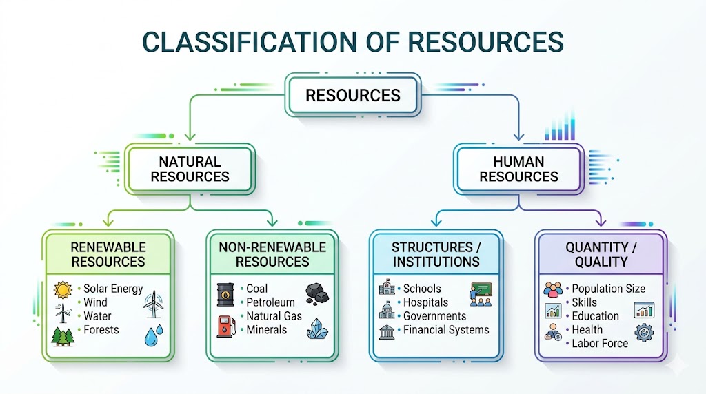
- Renewable Resources: Resources which can be renewed or reproduced by physical, chemical or mechanical processes. Examples: solar and wind energy, water, forests, and wildlife. (Further divided into continuous/flow like wind/water).
- Non-Renewable Resources: These occur over a very long geological time. They take millions of years in their formation. Some like metals are recyclable, and some like fossil fuels cannot be recycled and get exhausted with use. Examples: minerals and fossil fuels.
(c) On the Basis of Ownership
- Individual Resources: Owned privately by individuals. Examples: plots, houses, pasture lands, ponds, water in wells.
- Community Owned Resources: Accessible to all the members of the community. Examples: grazing grounds, burial grounds, village ponds, public parks, picnic spots.
- National Resources: Technically, all resources belong to the nation. The country has legal powers to acquire even private property for public good. Note: Oceanic area up to 12 nautical miles (22.2 km) from the coast is termed territorial water, and resources therein belong to the nation.
- International Resources: Regulated by international institutions. The oceanic resources beyond 200 nautical miles of the Exclusive Economic Zone belong to open ocean, and no individual country can utilise these without the concurrence of international institutions.
(d) On the Basis of the Status of Development
- Potential Resources: Resources found in a region but not yet utilised. Example: The western parts of India (Rajasthan and Gujarat) have enormous potential for solar and wind energy but have not been developed properly.
- Developed Resources: Resources which are surveyed, and their quality and quantity have been determined for utilisation. Development depends on technology and level of feasibility.
- Stock: Materials in the environment which have the potential to satisfy human needs, but humans do not have the appropriate technology to access them. Example: Water is a compound of hydrogen and oxygen. Hydrogen can be a rich source of energy, but we lack the advanced technology to use it for this purpose.
- Reserves: They are the subset of the 'stock', which can be put into use with the help of existing technical 'know-how', but their use has not been started yet. They are kept for meeting future requirements. Example: Water in the dams, forests, etc.
2. Development of Resources
Indiscriminate use of resources by human beings has led to the following major problems:
- Depletion of resources for satisfying the greed of a few individuals.
- Accumulation of resources in few hands, dividing the society into two segments i.e., haves and have-nots or rich and poor.
- Indiscriminate exploitation has led to global ecological crises such as global warming, ozone layer depletion, environmental pollution, and land degradation.
Important
Sustainable Economic Development: It means 'development should take place without damaging the environment, and development in the present should not compromise with the needs of the future generations.'
Concept
Rio de Janeiro Earth Summit, 1992:
In June 1992, more than 100 heads of states met in Rio de Janeiro in Brazil for the first International Earth Summit. The summit was convened for addressing urgent problems of environmental protection and socio-economic development at the global level. The assembled leaders signed the Declaration on Global Climatic Change and Biological Diversity and endorsed the global Forest Principles and adopted Agenda 21.
Agenda 21
- It is the declaration signed by world leaders in 1992 at the United Nations Conference on Environment and Development (UNCED), which took place at Rio de Janeiro.
- Aim: Achieving global sustainable development and combatting environmental damage, poverty, and disease through global co-operation.
- Major Objective: Every local government should draw its own local Agenda 21.
3. Resource Planning
Planning is the widely accepted strategy for judicious use of resources. It is crucial for a country like India, which has enormous diversity in the availability of resources.
- There are regions rich in certain types of resources but deficient in others.
- Example: Jharkhand, Chhattisgarh and MP are rich in minerals and coal deposits.
- Example: Arunachal Pradesh has abundant water resources but lacks infrastructural development.
- Example: Rajasthan is well endowed with solar and wind energy but lacks water resources.
- Example: The cold desert of Ladakh is isolated but has a very rich cultural heritage. It is deficient in water, infrastructure, and vital minerals.
- This calls for balanced resource planning at the national, state, regional, and local levels.
Resource Planning in India
Resource planning is a complex process which involves three main stages:
- Identification and inventory of resources across regions of the country. This involves surveying, mapping, and qualitative/quantitative estimation and measurement of resources.
- Evolving a planning structure endowed with appropriate technology, skill, and institutional set-up for implementing resource development plans.
- Matching the resource development plans with overall national development plans.
Fact
Conservation of Resources: Gandhiji voiced his concern about resource conservation by saying: "There is enough for everybody's need and not for anybody's greed." He placed the greedy and selfish individuals as the root cause for resource depletion and was against mass production, wanting to replace it with the production by the masses.
4. Land Resources
We perform our economic activities on land and we use it in different ways. Land is a natural resource of utmost importance, supporting natural vegetation, wildlife, human life, and economic activities. However, it is an asset of a finite magnitude.
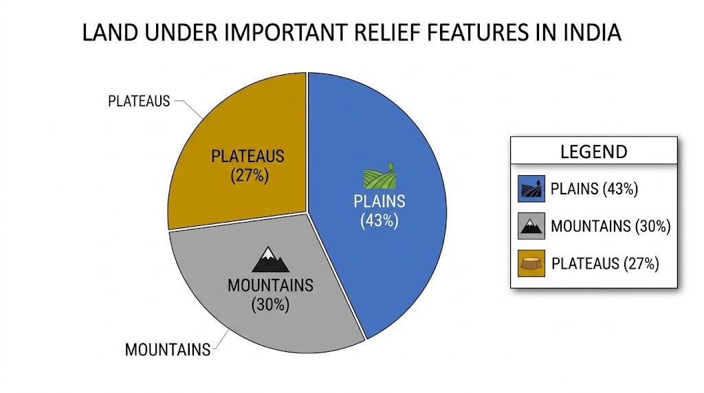
Relief Features of India
- Plains (43%): Provide facilities for agriculture and industry.
- Mountains (30%): Ensure perennial flow of some rivers, provide facilities for tourism and ecological aspects.
- Plateaus (27%): Possess rich reserves of minerals, fossil fuels, and forests.
Land Utilisation Categories
- Forests
- Land not available for cultivation:
- Barren and waste land.
- Land put to non-agricultural uses (buildings, roads, factories).
- Other uncultivated land (excluding fallow land):
- Permanent pastures and grazing land.
- Land under miscellaneous tree crops groves.
- Cultruable waste land (left uncultivated for more than 5 agricultural years).
- Fallow lands:
- Current fallow (left without cultivation for one or less than one agricultural year).
- Other than current fallow (left uncultivated for the past 1 to 5 agricultural years).
- Net Sown Area: The physical extent of land on which crops are sown and harvested.
Concept
Gross Cropped Area: Area sown more than once in an agricultural year plus net sown area is known as gross cropped area.
Land Use Pattern in India
Total geographical area of India is 3.28 million sq km. Land use data, however, is available only for 93% of the total geographical area because land use reporting for most of the north-east states (except Assam) has not been done fully, and some areas in J&K are occupied by Pakistan and China.
- The pattern of net sown area varies greatly from one state to another. It is over 80% of the total area in Punjab and Haryana, and less than 10% in Arunachal Pradesh, Mizoram, Manipur, and Andaman Nicobar Islands.
- Forest area is far lower than the desired 33% of geographical area, as outlined in the National Forest Policy (1952).
5. Land Degradation and Conservation Measures
Human activities have not only brought about degradation of land but have also aggravated the pace of natural forces to cause damage to land.
Causes of Land Degradation (State-wise)
This is extremely important for board exam map and matching questions:
- Mining: Mining sites are abandoned after excavation work is complete leaving deep scars and traces of over-burdening. States affected: Jharkhand, Chhattisgarh, Madhya Pradesh, and Odisha.
- Overgrazing: Unregulated grazing by cattle. States affected: Gujarat, Rajasthan, Madhya Pradesh, and Maharashtra.
- Over-irrigation: Responsible for land degradation due to water logging leading to increase in salinity and alkalinity in the soil. States affected: Punjab, Haryana, and western Uttar Pradesh.
- Mineral Processing: Grinding of limestone for cement industry and calcite/soapstone for ceramic industry generates huge quantities of dust in the atmosphere, which settles down and retards the infiltration of water into the soil.
- Industrial Effluents: Industrial waste has become a major source of land and water pollution in many parts of the country.
Conservation Measures
- Afforestation and proper management of grazing.
- Planting of shelter belts of plants.
- Control on overgrazing.
- Stabilisation of sand dunes by growing thorny bushes.
- Proper management of waste lands and control of mining activities.
- Proper discharge and disposal of industrial effluents and wastes after treatment.
6. Soil as a Resource
Soil is the most important renewable natural resource. It is the medium of plant growth and supports different types of living organisms on the earth. It takes millions of years to form soil up to a few cm in depth.
Factors of Soil Formation: Relief, parent rock or bed rock, climate, vegetation and other forms of life, and time. Forces of nature like change in temperature, actions of running water, wind and glaciers, activities of decomposers etc. contribute to the formation of soil.
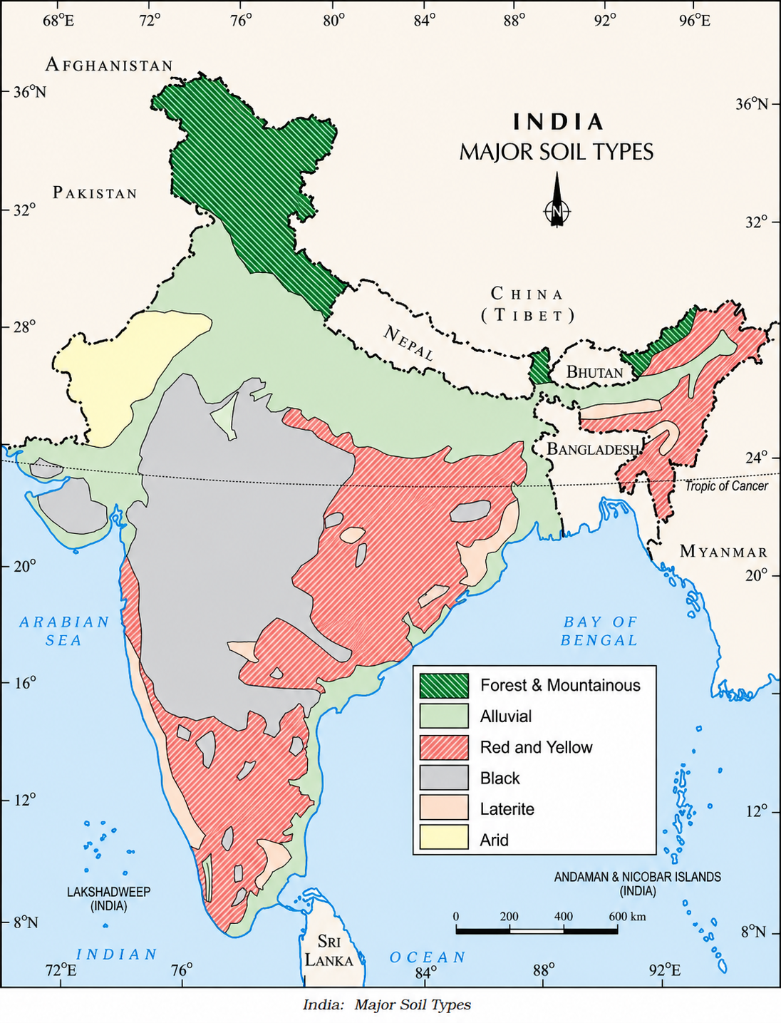
Classification of Soils
I. Alluvial Soils
- Importance: This is the most widely spread and important soil. The entire northern plains are made of alluvial soil.
- Formation: Deposited by three important Himalayan river systems: the Indus, the Ganga, and the Brahmaputra.
- Location: Northern plains, extending to Rajasthan and Gujarat through a narrow corridor. Also found in the eastern coastal plains particularly in the deltas of the Mahanadi, Godavari, Krishna, and Kaveri rivers.
- Composition: Contains adequate proportion of potash, phosphoric acid, and lime.
- Age Classification:
- Khadar (New Alluvial): More fine particles, more fertile, renewed frequently.
- Bangar (Old Alluvial): Higher concentration of kanker (calcareous) nodules, less fertile.
- Crops: Ideal for the growth of sugarcane, paddy, wheat, and other cereal and pulse crops. Regions are intensively cultivated and densely populated.
II. Black Soil
- Also known as: Regur soil or Black cotton soil.
- Formation: Climatic condition along with the parent rock material (basalt) are the important factors for its formation.
- Location: Typical of the Deccan trap (Basalt) region spread over northwest Deccan plateau (Maharashtra, Saurashtra, Malwa, Madhya Pradesh, Chhattisgarh).
- Composition: Made up of extremely fine i.e. clayey material. Well-known for their capacity to hold moisture. Rich in soil nutrients, such as calcium carbonate, magnesium, potash, and lime. Poor in phosphoric contents.
- Special Feature: They develop deep cracks during hot weather, which helps in the proper aeration of the soil. These soils are sticky when wet and difficult to work on unless tilled immediately after the first shower.
III. Red and Yellow Soils
- Formation: Develops on crystalline igneous rocks in areas of low rainfall.
- Location: Eastern and southern parts of the Deccan plateau, parts of Odisha, Chhattisgarh, southern parts of the middle Ganga plain.
- Colour: Develops a reddish colour due to diffusion of iron in crystalline and metamorphic rocks. It looks yellow when it occurs in a hydrated form.
IV. Laterite Soil
- Name Origin: Derived from the Latin word 'later' which means brick.
- Formation: Develops under tropical and subtropical climate with alternate wet and dry season. This soil is the result of intense leaching due to heavy rain.
- Features: Mostly deep to very deep, acidic (pH < 6.0), generally deficient in plant nutrients. They are prone to degradation and erosion.
- Location: Mostly in southern states, Western Ghats region of Maharashtra, Odisha, some parts of West Bengal and North-east regions.
- Crops: Very useful for growing Tea and Coffee (in Karnataka, Kerala, Tamil Nadu). Red laterite soils in Tamil Nadu, Andhra Pradesh, and Kerala are eminently suitable for crops like cashewnut.
V. Arid Soils
- Colour & Texture: Range from red to brown in colour. Generally sandy in texture and saline in nature.
- Features: Due to dry climate and high temperature, evaporation is faster and the soil lacks humus and moisture.
- Composition: The lower horizons of the soil are occupied by Kankar because of the increasing calcium content downwards, which restricts the infiltration of water.
- Location: Western Rajasthan. Can become cultivable after proper irrigation.
VI. Forest Soils
- Location: Found in the hilly and mountainous areas where sufficient rain forests are available.
- Features: The soils texture varies according to the mountain environment where they are formed. They are loamy and silty in valley sides and coarse grained in the upper slopes.
- Snowbound areas: In the snow-covered areas of Himalayas, these soils experience denudation and are acidic with low humus content.
7. Soil Erosion and Soil Conservation
Concept
Soil Erosion: The denudation of the soil cover and subsequent washing down is described as soil erosion. The processes of soil formation and erosion go on simultaneously, but the balance is disturbed by human activities (deforestation, over-grazing, construction, mining) and natural forces (wind, glacier, water).
Types of Water Erosion
- Gully Erosion: The running water cuts through the clayey soils and makes deep channels as gullies. The land becomes unfit for cultivation and is known as bad land. In the Chambal basin, such lands are called ravines.
- Sheet Erosion: Sometimes water flows as a sheet over large areas down a slope. In such cases, the top soil is washed away.
- Wind Erosion: Wind blows loose soil off flat or sloping land.
Soil Conservation Techniques
- Contour Ploughing: Ploughing along the contour lines can decelerate the flow of water down the slopes.
- Terrace Farming: Steps can be cut out on the slopes making terraces. Terrace cultivation restricts erosion. Extensively used in Western and Central Himalayas.
- Strip Cropping: Large fields are divided into strips. Strips of grass are left to grow between the crops. This breaks up the force of the wind.
- Shelter Belts: Planting lines of trees to create shelter. These shelter belts have contributed significantly to the stabilisation of sand dunes and in stabilising the desert in western India.
Important Previous Year Questions (PYQs)
Q & A
Q1. Differentiate between Stock and Reserve resources with examples.
Ans: Stock refers to materials in the environment that have the potential to satisfy human needs, but human beings do not have the appropriate technology to access them (e.g., extracting energy from hydrogen and oxygen in water). Reserves are the subset of stock that can be put into use with existing technology, but their use has not started yet; they are kept for future requirements (e.g., water in dams).
Q & A
Q2. Write a short note on Agenda 21.
Ans: It is the declaration signed by world leaders in 1992 at the United Nations Conference on Environment and Development (UNCED) at Rio de Janeiro, Brazil. Its aim is to achieve global sustainable development. Its major objective is that every local government should draw its own local Agenda 21 to combat environmental damage, poverty, and disease.
Q & A
Q3. Explain the main causes of land degradation in India.
Ans:
- Mining: In states like Jharkhand, Chhattisgarh, and Odisha, mining has left deep scars and traces of over-burdening.
- Overgrazing: Unregulated grazing in Gujarat, Rajasthan, and Maharashtra has degraded land.
- Over-irrigation: In Punjab and Haryana, over-irrigation causes waterlogging, leading to increased salinity and alkalinity.
- Industrial Effluents: Untreated industrial waste pollutes land and water.
Q & A
Q4. Distinguish between Khadar and Bangar soil.
Ans: Khadar is the new alluvial soil, found closer to river basins. It is renewed frequently, has finer particles, and is more fertile. Bangar is the old alluvial soil found further away from the river. It contains a higher concentration of 'kankar' (calcareous nodules) and is relatively less fertile than Khadar.
Q & A
Q5. What is the importance of Contour Ploughing and Shelter Belts?
Ans: Contour ploughing involves ploughing along contour lines of a slope, which acts as a barrier to decelerate the downward flow of water, preventing soil erosion. Shelter belts are lines of trees planted to break the force of the wind. They are highly effective in preventing wind erosion and stabilising sand dunes, particularly in desert regions.

 and 'C.jpg)