Q1. What are the sources of energy that are required to cause movements associated with the internal forces of the Earth?
Answer
The internal forces of the Earth (endogenic forces) are primarily driven by heat from the Earth's interior. The main sources of this energy are:
- Radioactive Decay: Heat generated by the decay of radioactive elements (like uranium, thorium, and potassium) in the Earth's mantle and crust.
- Primordial Heat: The residual heat retained from the time of Earth's formation.
This immense heat causes convection currents in the mantle, which in turn drive the movement of tectonic plates.
Q2. Relate various physiographic divisions you have studied in the earlier grades with various endogenic forces responsible for their origin.
Answer
Various physiographic divisions of the Earth are formed by different endogenic (internal) forces:
- The Himalayas (Fold Mountains): Formed by the convergent movement of tectonic plates (the Indo-Australian Plate colliding with the Eurasian Plate), causing the Earth's crust to fold upwards.
- The Deccan Plateau: Formed by prolonged volcanic activity (fissure eruptions) where lava spread over large areas and solidified over millions of years.
- Rift Valleys (e.g., Narmada Valley): Formed due to faulting, where tectonic plates diverge or crack under tensional forces, causing land to subside between the cracks.
Q3. Why and where do earthquakes occur frequently? Is it possible to predict earthquakes?
Answer
Why do they occur? Earthquakes occur due to the sudden release of energy in the Earth's crust that creates seismic waves. This usually happens when tectonic plates get stuck at their edges due to friction and then suddenly slip or break.
Where do they occur? They most frequently occur along the boundaries of tectonic plates, especially in regions known as the "Ring of Fire" around the Pacific Ocean, and along the Himalayan mountain belt.
Can they be predicted? No, it is currently not possible to accurately predict the exact time and date of earthquakes. However, scientists can estimate the probability of earthquakes occurring in specific high-risk fault zones.
Q4. "Plate movements are responsible for the distribution of earthquakes and volcanoes." Explain.
Answer
The Earth's lithosphere is broken into several tectonic plates that are constantly in motion. The interaction of these plates at their boundaries is the primary cause of earthquakes and volcanoes:
- Volcanoes: Mostly occur at divergent plate boundaries (where plates pull apart, allowing magma to rise) and convergent plate boundaries (where one plate subducts under another, melting and forming magma).
- Earthquakes: Happen when these plates grind past each other (transform boundaries), collide, or pull apart. This movement causes tremendous stress to build up and release suddenly.
Therefore, the global distribution of both earthquakes and volcanoes closely aligns with the margins of these tectonic plates.
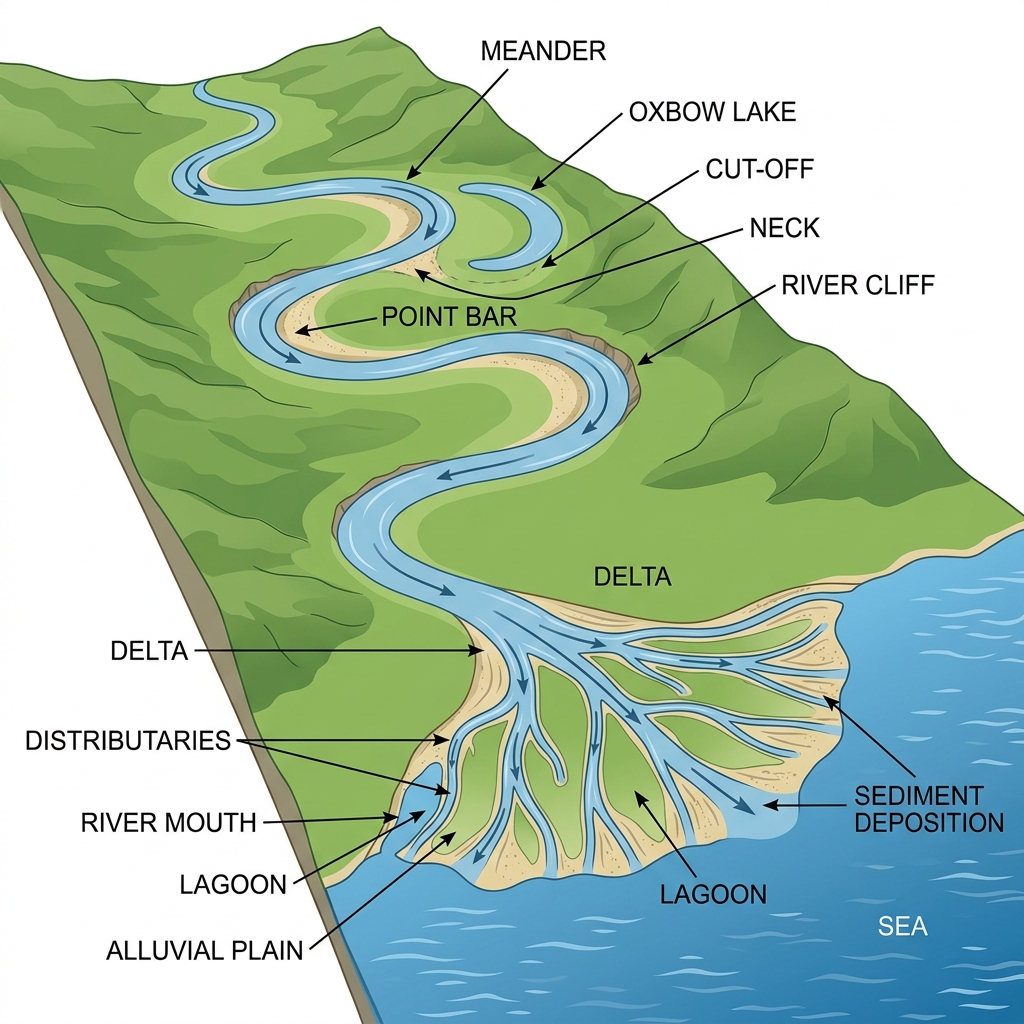
Q5. Draw and label a diagram of a meander and a delta.
Answer
Below is a geographical diagram illustrating a river meander and a delta:
Q6. How are deforestation and erosion associated with each other? Explain.
Answer
Deforestation drastically increases the rate of soil erosion due to the following reasons:
- Loss of Root Binding: Trees and plants hold the soil together tightly with their root systems. Deforestation removes this anchor, making the loose soil highly susceptible to being washed away by water or blown away by wind.
- Loss of Canopy Cover: Tree canopies intercept rainfall, reducing the direct impact of raindrops on the soil surface. Without trees, heavy rain directly pounds the soil, increasing surface runoff and topsoil removal.
- Reduction in Organic Matter: Forests continuously add organic matter (humus) to the soil, improving its structure and water retention. Deforestation degrades soil structure, accelerating erosion.
Q7. Develop a plan to protect the land in your local area from erosion. (Activity)
Activity Guide
To protect local land from erosion, the following comprehensive plan can be implemented:
- Afforestation: Plant more trees, native shrubs, and grasses to naturally bind the soil and increase vegetative cover.
- Terrace Farming: If the area has slopes or hills, encourage step or terrace farming to slow down the speed of water runoff.
- Check Dams: Build small stone or wooden check dams across streams to reduce water velocity and prevent deep gully erosion.
- Windbreaks: Plant rows of tall trees along the edges of agricultural fields to protect the topsoil from being carried away by strong winds.
Q8. Which disasters do you think you might experience in your region? Discuss a mitigation plan in your classroom. (Activity)
Activity Guide
*(Note: Answers will vary based on the student's actual region. Below is an example for Northern India)*
In our region, we are primarily vulnerable to Earthquakes and Floods.
Earthquake Mitigation Plan: Ensure all new buildings follow seismic building codes. Conduct regular drop-cover-hold drills in schools and offices. Secure heavy furniture to walls to prevent them from falling.
Flood Mitigation Plan: Improve local drainage systems and clean them before the monsoon season. Avoid constructing buildings in natural floodplains. Promote rainwater harvesting to manage excess water.
Q9. Prepare a model of landforms created by underground water. (Activity)
Activity Guide
This is a practical hands-on activity. Students can use clay, Plaster of Paris, or paper mache to build a cross-section model of a limestone cave. Key features to model and label include:
- Sinkholes on the surface.
- Stalactites hanging from the cave ceiling.
- Stalagmites rising from the cave floor.
- Underground streams or pools of water.
Q10. What precautionary measures will you take if you are staying in an earthquake-prone region?
Answer
If living in an earthquake-prone area, the following precautions should be taken:
- Before: Secure heavy furniture, water heaters, and appliances to the walls. Prepare an emergency kit containing water, non-perishable food, a first-aid kit, and a flashlight. Identify safe spots in every room (like under a sturdy desk).
- During: Remember to Drop, Cover, and Hold on. Stay away from glass windows and outside doors. If you are outdoors, move to an open area away from buildings, trees, and power lines.
- After: Check for injuries and apply first aid. Be prepared for aftershocks. Listen to a battery-operated radio for emergency broadcasts and do not use elevators.
Q11. Prepare a map showing landform-associated disasters that happened in the current calendar year. (Activity)
Activity Guide
Students should use a blank political map of India or the World. Using news reports from the current year, mark the locations of recent disasters. For example, mark the Himalayan region (Himachal Pradesh, Uttarakhand) for landslides, the North-Eastern states for floods, or regions in Japan/Turkey for earthquakes. Use different colored symbols (e.g., triangles for landslides, waves for floods) to differentiate the disasters and include a legend.
Q12. Create a poster showing landforms that are considered to be sacred or important in your region, and add the folk stories associated with them. (Activity)
Activity Guide
This is a creative arts and culture activity. Identify a local geographical feature (like a hill, river, or lake) that holds religious or cultural significance. Draw or paste a picture of it on a chart paper. Below the image, write a short paragraph explaining the local folk story, myth, or historical event that makes this landform sacred to the local community.
Q13. Document a case of a disaster that hit your region in the past, highlighting its effects on various human activities. (Activity)
Activity Guide
Conduct research on a major historical disaster in your state or country (e.g., the 2001 Gujarat Earthquake, the 2013 Kedarnath Floods, or the 2004 Indian Ocean Tsunami). Write a short report highlighting:
- The cause and magnitude of the disaster.
- The immediate destruction of infrastructure (roads, bridges, houses).
- The long-term impact on agriculture, local businesses, and daily human life.
- The recovery process and lessons learned for future mitigation.
Q14. Translate the given poster on landslide into your native language and display it in your home. (Activity)
Activity Guide
Refer to the "LANDSLIDE: Ready Now to stay secure" poster in the textbook (which outlines Before, During, and After precautions). Translate the key points such as "Grow more trees", "Stay calm, do not panic", and "Move away from landslide path" into your mother tongue (e.g., Hindi, Bengali, Tamil, etc.). Design a visually appealing poster with these translated points and place it in a visible area at home.
Q15. Divide the class into three groups. Each group will work on one project (water, wind, and glacier). The project should highlight the causes, impact on human life and the environment, and mitigation measures. (Activity)
Activity Guide
Here are key points each group should cover in their project:
- Group 1 (Water/Floods): Focus on how heavy rainfall and poor urban drainage cause floods. Discuss the impact on crop destruction and waterborne diseases. Suggest mitigation measures like building dams, reinforcing river embankments, and afforestation.
- Group 2 (Wind/Cyclones): Focus on how low-pressure atmospheric systems form cyclones. Discuss the impact of high-speed winds uprooting trees and destroying coastal infrastructure. Suggest mitigation measures like building underground cyclone shelters and planting mangrove forests along the coast.
- Group 3 (Glaciers/Avalanches): Focus on how global warming and steep unstable slopes trigger avalanches or glacial lake outburst floods (GLOFs). Discuss the impact on mountain communities and flash floods in valleys. Suggest mitigation measures like installing early warning systems and strictly prohibiting construction in vulnerable zones.