Vardaan Learning Institute
Shaping of the Earth's Surface
The Big
Questions
- What shapes the Earth's surface?
- What is plate tectonics? What are the effects of plate movement?
- How are landforms formed and how are they classified?
- How are humans and other living beings connected to these landforms?
- How do disasters associated with different landforms impact human lives?
1. Introduction to the Earth's Surface
The Earth's surface is not consistent; it is constantly being transformed by powerful forces acting from
within and on the surface of the planet.
Key Definition
Landforms: A landform is a natural feature on the Earth's surface formed by processes,
such as weathering, erosion, deposition, and the movement of the Earth's crust. Examples include
mountains, valleys, plateaus, plains, deserts, and coastal features.
2. Plate Tectonics and Earth's Interior
One of the most important ideas that explains these changes is the theory of plate
tectonics, proposed by W.J. Morgan. According to this theory, the outermost layer of the Earth
is not one single piece but is broken into several large and small pieces called tectonic
plates.
These plates move slowly over the semi-molten layer beneath them and are responsible for major physical
features and natural phenomena, such as mountains, earthquakes, and volcanoes.
Layers of the Earth
The Earth is made up of three main layers:
- Crust: The outermost layer on which we live. Thickness varies from 30–40 km under
continents to 5–7 km under the ocean.
- Mantle: A very thick and hot layer below the crust. (approx. 2900 km thick). It
contains the Asthenosphere, a hot, mobile layer of partially molten rock.
- Core: The innermost layer, extremely hot and heavy. It is divided into an Outer
Core (fluid layer of iron and nickel, approx. 2200 km) and an Inner Core (solid, hot
spinning metal ball, approx. 1250 km).
Lithosphere: Formed by the crust along with the upper rigid part of the mantle (approx. 100
km). It is this lithosphere that is broken into tectonic plates.
.png)
Figure 2.1: The Earth's interior
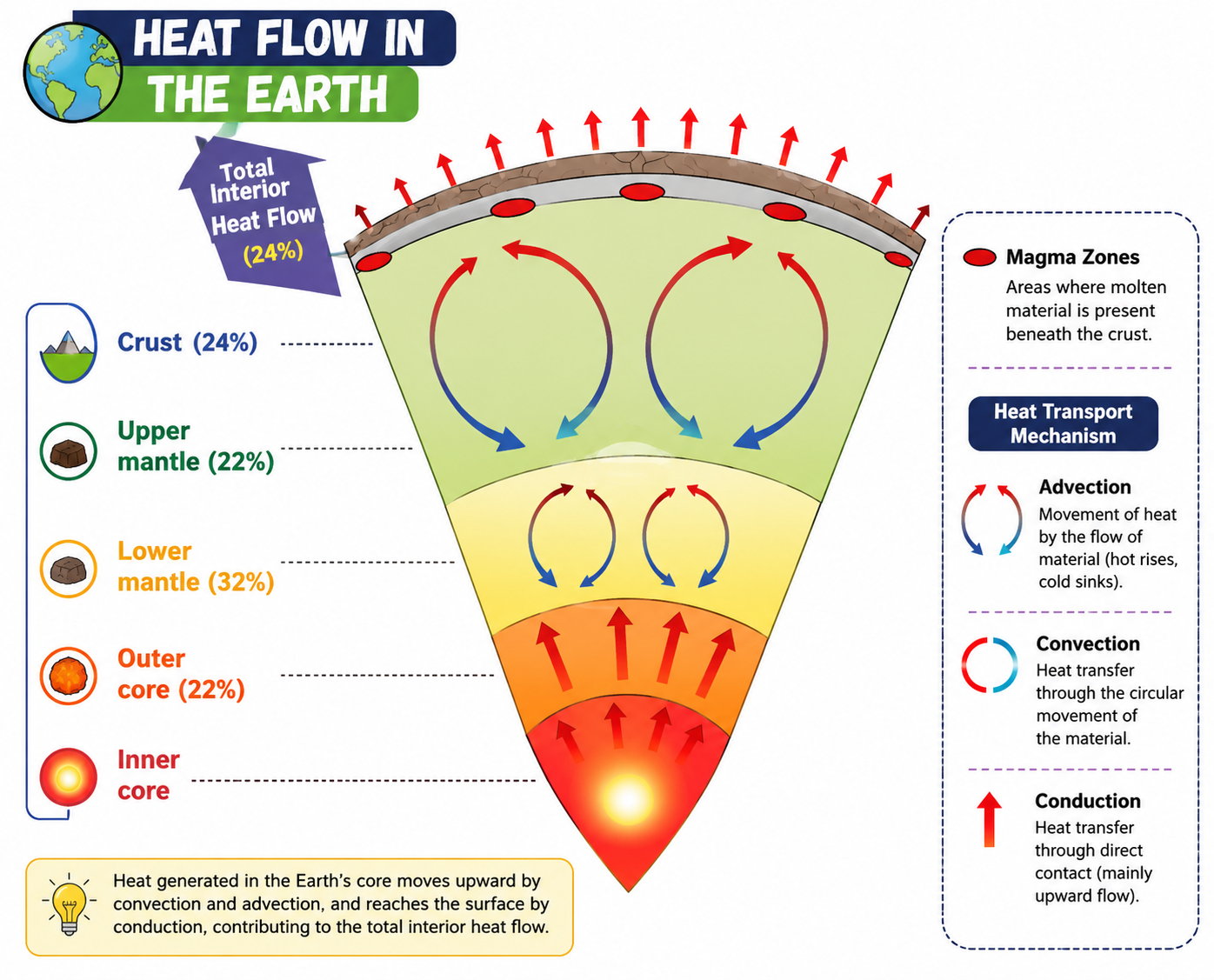
Figure 2.2: Movement of material below the crust
3. Tectonic Plates and Convection Currents
Tectonic plates are massive slabs of solid rock that move very slowly, usually a few centimetres per year.
- Continental Plates: Carry continents.
- Oceanic Plates: Carry ocean floors.
- Mixed Plates: Carry both continents and oceans.
Major plates include: Pacific Plate, Eurasian Plate, African Plate, North American Plate, South American
Plate, Indo-Australian Plate, and Antarctic Plate.
What Causes Plates to Move?
The movement of tectonic plates is caused by convection currents in the mantle. Heat from
the Earth's core causes molten material in the mantle to rise, while cooler material sinks. This continuous
movement pushes and pulls the tectonic plates.
4. Plate Boundaries
The edges where tectonic plates meet are called plate boundaries. There are three main
types:
Types of Boundaries
- Convergent Boundary: Where two plates move towards each other.
- Continent-Continent collision: Forms fold mountains (e.g., Himalaya).
- Ocean-Continent collision: Oceanic plate sinks beneath the continental plate, leading to
volcanic activity and earthquakes.
- Divergent Boundary: Where plates move away from each other. Magma rises from below
to form new crust (e.g., Mid-Atlantic Ridge).
- Transform Boundary: Where plates slide past each other without creating or
destroying crust. Mainly causes earthquakes (e.g., San Andreas Fault).
5. Global Distribution of Earthquakes and Volcanoes
Plate tectonics explains the distribution of continents, oceans, and natural disasters. Most earthquakes and
volcanoes occur along plate boundaries, especially around the Pacific Ocean, an area famously known as the
Ring of Fire.
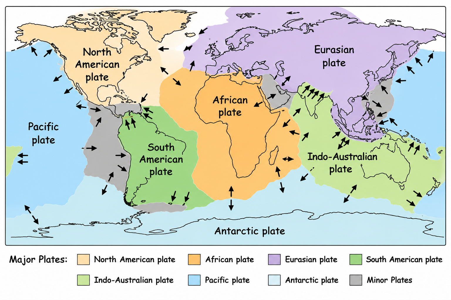
Figure 2.3: World map showing major plates and their direction of movement
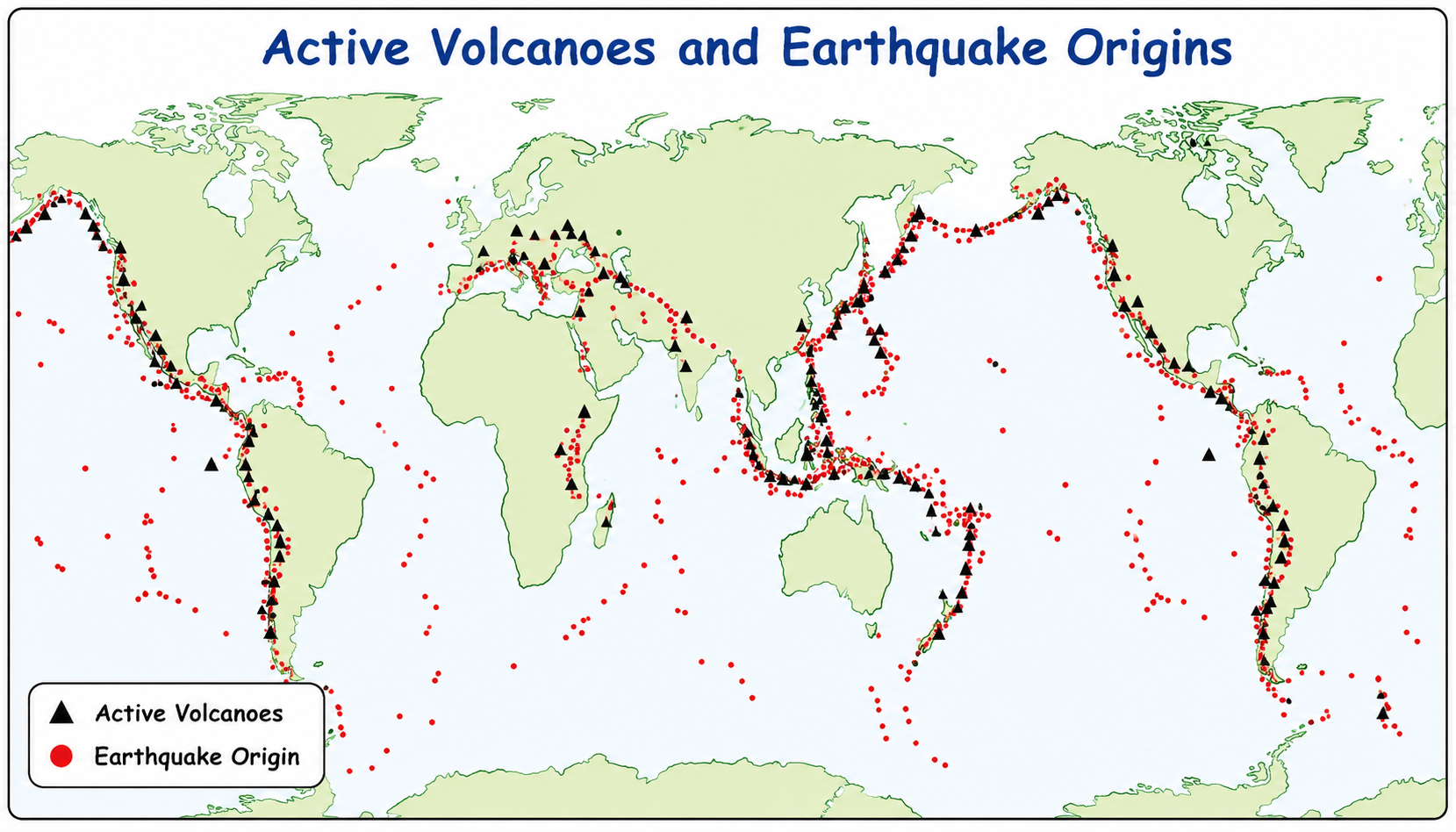
Figure 2.4: Map showing the distribution of earthquakes and volcanoes
6. Impacts on Human Lives and Traditional Knowledge
The movement of plates leads to the formation of our habitats (valleys, mountains, plains) but also causes
disasters like earthquakes and volcanic eruptions.
India's Vulnerability
India is a densely populated country that has experienced major earthquakes resulting in severe damage to
life and environment (e.g., the 2001 Gujarat earthquake). Understanding tectonic theory is vital for
identifying these vulnerable zones and managing disasters.
Traditional
Knowledge (Don't Miss Out)
In early times, earthquakes were known as 'bhūkampa' (shaking of the Earth). In the
Brihatsamhitā, ancient Indian scholar Varāhamihira dedicated a section to earthquakes. He noted
how environmental changes (wind, clouds, animal behavior) signaled them, and attributed them to four
elemental forces:
- Vāyu (Wind)
- Agni (Fire)
- Indra (Heaven/Thunder)
- Varuṇa (Water)
This reflects an early scientific attempt in India to blend observations of physical phenomena with
cosmological reasoning.
7. Process of Weathering and Erosion
Weathering and erosion play a vital role in the development of landforms by continuously breaking down and
reshaping the Earth's surface. Over long periods, they wear down mountains, carve valleys, form plains, and
create diverse landscapes like caves, cliffs, and river deltas.
Weathering
Weathering is the process through which rocks on the Earth's surface break down into smaller pieces. It does
not involve movement of the broken material, only the breaking down.
Types of Weathering
- Physical weathering: Rocks break into smaller pieces due to temperature changes,
frost, or wind.
- Chemical weathering: Minerals in rocks change because of reactions with water, air,
or acids, leading to new substances.
- Biological weathering: Caused by plants, animals, or micro-organisms (e.g., plant
roots growing into rock cracks and splitting them).
Erosion and Its Impacts
Erosion is the process by which soil, rocks, and surface materials are worn away and carried from one
place to another by natural agents. Unlike weathering, erosion involves movement.
- Water erosion: Caused by rivers, rain, or ocean waves.
- Wind erosion: Common in dry and sandy areas.
- Glacial erosion: Moving ice scrapes and carries rocks.
- Coastal erosion: Sea waves wear away land along the shore.
Impact on Human Livelihoods: Erosion removes fertile topsoil for farmers, washes away land
and homes near coasts, destabilizes construction, and negatively impacts industries like tourism and
fishing.
Traditional
Conservation Methods
Ancient civilizations, including the Sindhu-Sarasvati civilisation, employed sophisticated water and soil
management techniques, documented in texts like the Arthaśhāstra. The Zabo
system in Nagaland is another great example of integrated farming and conservation.
- Contouring: Digging continuous contour trenches (CCT) along a hillside to slow down
and hold rainwater.
- Bunding: Earthen embankments built along contour lines to slow run-off.
- Terracing: Creating a series of level steps on a hillside to prevent soil erosion.
8. Agents of Gradation
Agents of gradation are natural forces that wear down, transport, and deposit materials,
helping to level or smooth the Earth's surface over time. The main agents are running water,
glaciers, wind, waves, and groundwater.
Landforms and Human History
Landforms have deeply influenced human civilisation:
- Rivers & Plains: Ganga, Nile, and Indus gave rise to early agricultural societies.
- Mountains: The Himalayas acted as protectors from invasions but allowed cultural
exchange through passes (e.g., Khyber pass).
- Deserts: The Thar desert limited large settlements but encouraged trade routes like
the Silk Route.
- Coasts: Harbours supported trade and cultural contacts (e.g., South Indian
kingdoms).
Running Water and River Landforms
Rivers shape the land through erosion, transportation, and deposition across three main stages of their
course:
- Upper Course: Steep gradients and strong erosive forces create V-shaped
valleys, waterfalls, and rapids.
*A waterfall forms when hard rocks resist erosion while softer rocks below are worn away,
creating a sudden vertical drop.
- Middle Course: The river starts to meander as it loses energy, forming
oxbow lakes and floodplains.
- Lower Course: The river slows down significantly and deposits large amounts of
sediment, creating deltas, levees, and alluvial fans.
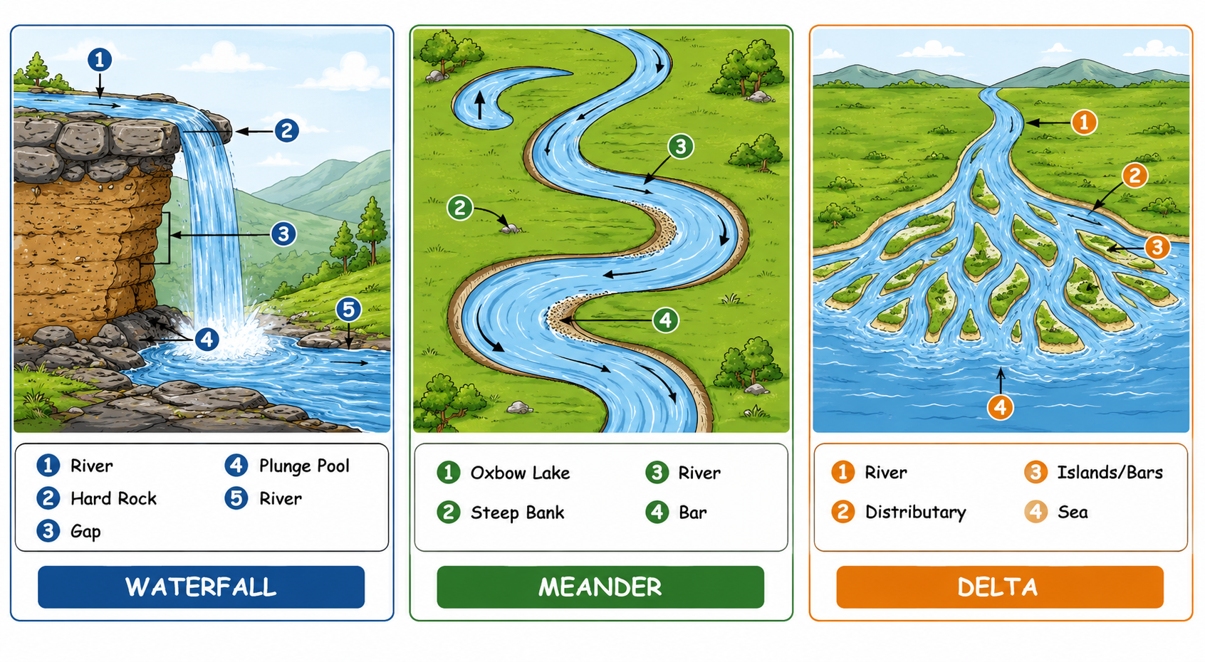
Figure 2.10, 2.11, & 2.12: River Landforms: Waterfall, Meander, and Delta
Benefits of River Features:
- Waterfalls: Used for hydroelectric power generation and attract
tourists.
- Meanders: Provide fertile soil on their banks for agriculture, and are often used for
navigation and irrigation (e.g., The Grand Anicut / Kallanai in Tamil Nadu).
- Deltas: Highly fertile areas with rich alluvial soil, ideal for agriculture (like rice
and jute). They are also centres for fishing, trade, and transportation.
9. Waves and Currents
Waves and currents are constantly moving over the oceanic surface, reshaping the land along the coastal zone.
They create landforms such as beaches, sand bars, sea cliffs, sea caves, arches, and
stacks.
Beaches
A beach is a landform made up of sand, pebbles, or rocks along the shoreline created by the
deposition of sediments by waves. They boost the local economy through tourism and recreation, provide
fishing areas, and act as natural barriers against coastal erosion.
Coastal Erosion Landforms
When waves wear away the land, unique landforms emerge:
- Cliffs: Steep rock faces formed as waves undercut the base of the coast.
- Wave-cut platforms: Flat areas left behind as cliffs retreat.
- Caves: Formed when waves erode weak parts of the rock.
- Arches: Created when caves on opposite sides of a headland meet.
- Stacks: Isolated pillars of rock left standing after arches collapse.
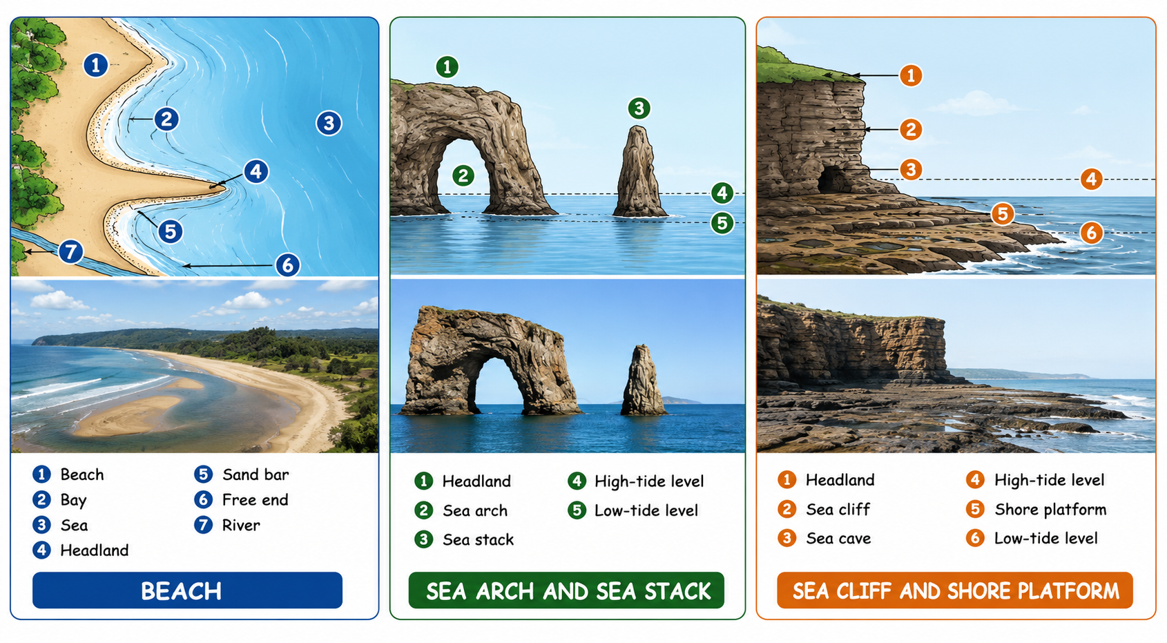
Figure 2.14, 2.15, & 2.16: Coastal Landforms: Beach, Sea Arch/Stack, and Sea Cliff/Platform
10. Glaciers
Glacial erosion occurs when glaciers (massive bodies of ice) slowly move over the land, carving and shaping
the landscape. They are crucial sources of fresh water, feeding rivers that sustain human populations
downstream.
Glacial Landforms
- U-shaped valleys: Formed as glaciers widen and deepen river valleys.
- Cirques: Bowl-shaped depressions at the head of a glacier.
- Aretes: Sharp ridges between valleys.
- Hanging valleys: Occur where smaller glaciers meet larger ones.
- Fjords: Deep, narrow inlets created when the sea floods glacial valleys (often used
for harbours).
Moraines
Moraines are landforms created by the deposition of rocks, soil, and debris (called
till) carried along and left behind by glaciers as they melt.
- Lateral moraines: Form along the sides of glaciers.
- Terminal moraines: Found at the end of glaciers, marking their furthest advance.
- Medial moraines: Formed when two glaciers meet and their lateral moraines join in the
middle.
Moraines are important because they create fertile soil for agriculture and can form natural dams/lakes used
for water supply and hydroelectric power.
11. Wind
Wind erosion occurs when strong winds pick up and carry away loose particles of sand and soil, gradually
shaping the landscape, especially in arid and desert regions.
Desert Landforms
- Yardangs: Streamlined rock ridges carved by wind.
- Ventifacts: Rocks polished and shaped by sandblasting.
- Deflation hollows (blowouts): Shallow depressions formed where loose material is
removed. Sometimes these can reach the water table, creating an oasis.
- Desert pavements: Flat surfaces left behind after finer particles are blown away.
Dunes
Dunes are hills or ridges of sand formed by the wind. They act as natural barriers against
desertification and protect coastal settlements from strong sea winds. Types of dunes include:
- Barchan dunes: Crescent-shaped dunes formed in areas with limited sand and a single
wind direction.
- Longitudinal/Transverse dunes: Long ridges formed parallel or perpendicular to the
wind.
- Star dunes: Dunes with multiple arms formed where winds come from different directions.
- Parabolic dunes: U-shaped dunes often stabilised by vegetation.
12. Underground Water
Underground water creates unique landforms called Karst topography through chemical
weathering and erosion, especially in areas of limestone or soluble rocks.
Karst Landforms
- Caves: Hollow spaces formed as acidic water dissolves rock.
- Stalactites: Icicle-shaped formations hanging from the ceiling of caves.
- Stalagmites: Formations rising from the floor of caves.
- Sinkholes (dolines): Depressions formed when the ground collapses into an
underground cavity.
- Underground rivers: Rivers which flow through these cave systems.
These landforms provide crucial sources of fresh water, tourism opportunities, and often hold cultural
significance.
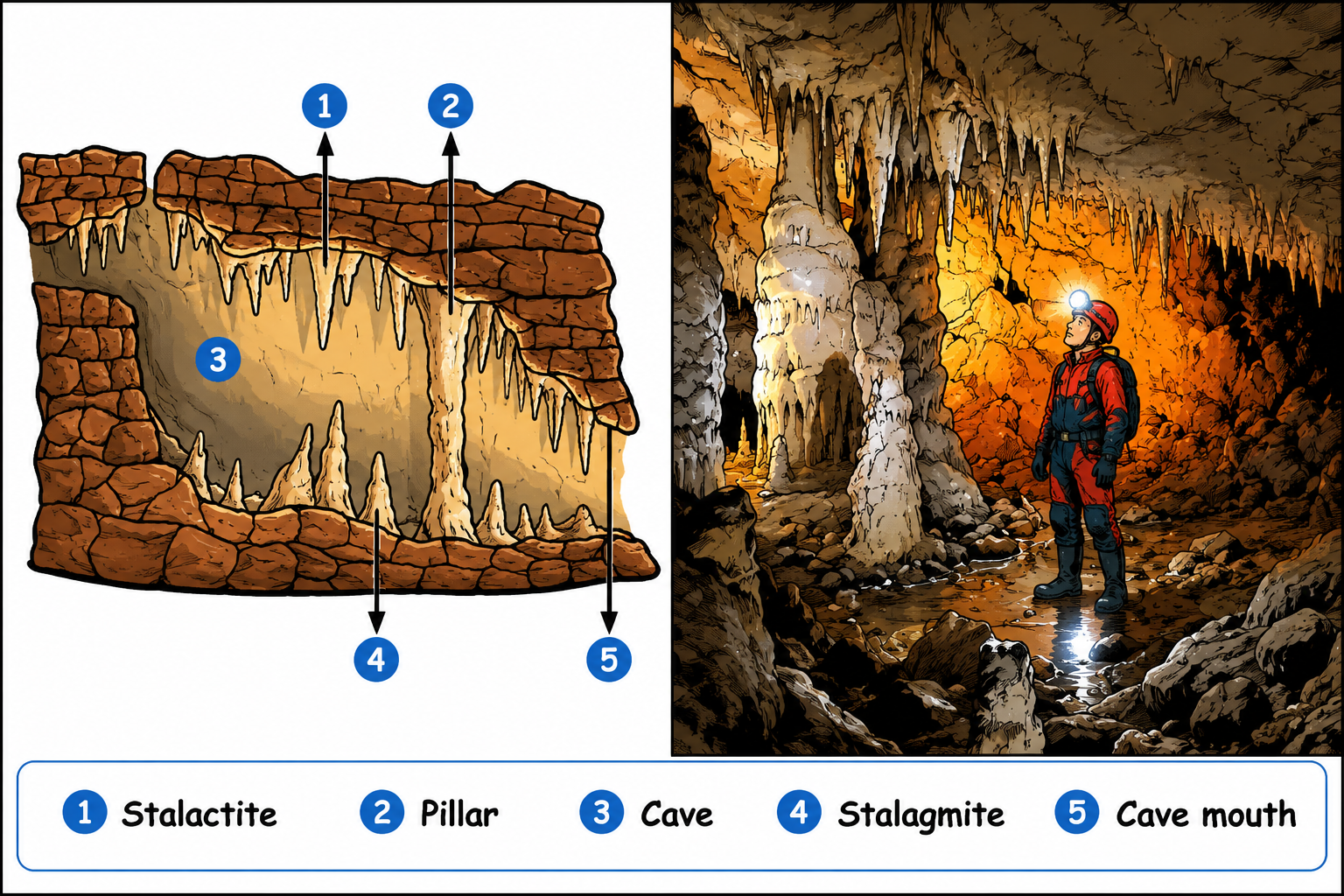
Figure 2.24: Underground Landforms: Cave structures
13. Landforms and Disasters
There are several natural disasters closely associated with different landforms and environmental conditions.
Human activities often exacerbate these hazards.
Major
Disasters
- Landslides: Triggered by heavy rainfall, earthquakes, or human activities
(deforestation, road construction) which make steep slopes unstable, causing soil and rock to slide
down.
- Avalanches: Sudden instability of snow on steep mountain slopes caused by heavy
snowfall, temperature rises, or vibrations (natural or human).
- GLOFs (Glacial Lake Outburst Floods): The sudden release of water from glacial
lakes due to rapid glacier melting, earthquakes, or landslides weakening the natural ice/moraine
dams.
- Dust Storms: Caused by strong winds lifting dry soil in arid regions, worsened by
prolonged drought, deforestation, and poor farming practices.
Conclusion: Before We Move On...
The Earth's surface is constantly changing due to powerful forces working both inside and outside the planet.
- The Earth is made up of layers: the crust, mantle, and core.
- Internal forces (earthquakes, volcanoes, folding, faulting) are responsible for moving
the crust.
- External forces (weathering and erosion) carve smaller landforms over the Earth's
surface.
- The surface is sculpted by agents of gradation: running water, waves, glaciers, wind,
and underground water.
- Specific landforms are associated with disasters like landslides, avalanches, GLOFs, and sandstorms.
Understanding these natural processes helps us appreciate nature's power and prepare wisely for natural
disasters, ensuring a safer and more sustainable relationship with our planet.

 VARDAAN COMET